Phoenix
A NASA Mission to the Polar Regions of Mars
 The Phoenix mission owes its name to the heritage from precursor missions that either failed (Mars Polar Lander, 1999) or were cancelled at a late stage (Mars Surveyor Lander 2001). The Phoenix spacecraft was successfully launched on Aug. 4, 2007 and shall land on May 25, 2008 in the Martian arctic region. It shall analyze near-surface water ice that is expected at the landing site. The Primary Mission lasts 90 sols and is followed by the Polar Climate Phase (60 sols). The mission will end late in 2008 due to lack of solar power.
Science objectives
- Analyze ice-rich soil: Data from Mars Odyssey (in orbit since 2001) suggest the presence of water ice at shallow depths (< 1 m) at the Phoenix landing site (~ 68.3°N, 127°W; see plus sign in the figures). The Phoenix mission shall test this hypothesis.
- Search for organic molecules that might be enclosed in the ice.
- Study the physicochemical properties of the soil (grain size, magnetic properties, thermal and electrical conductivity, pH, soluble ions).
- Study the exchange of water vapor between soil and atmosphere. Search for clouds.
- Measure pressure and temperature over the entire mission time.
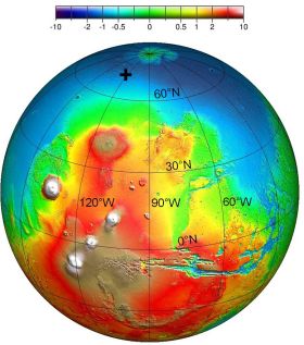 Topography of the "Tharsis side" of Mars as inferred from MOLA data (Mars Orbital Laser Altimeter) aboard the Mars Global Surveyor spacecraft. The color indicates the altitude (in km) above/below the MOLA surface reference. The Phoenix landing site (~ 68.3°N, 127°W) is marked by a plus sign. Credit: MGS/MOLA.
|
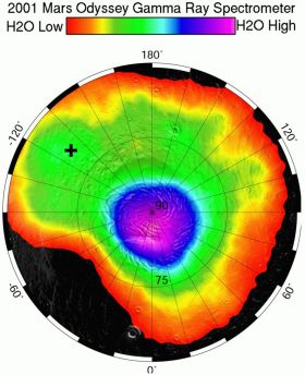 Abundance of near-surface water ice in the northpolar region of Mars (including the Phoenix landing site that is marked by a plus sign). Credit: Mars Odyssey, GRS.
|
The Launch
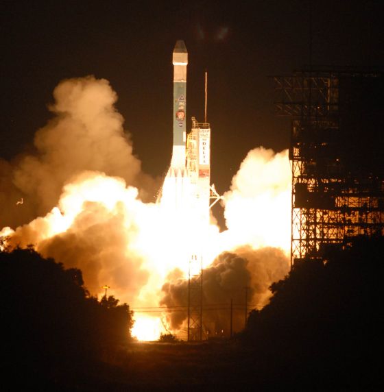
The Phoenix spacecraft was successfully launched on Aug.4, 2007, aboard a Delta II rocket from Cape Canaveral, Florida.
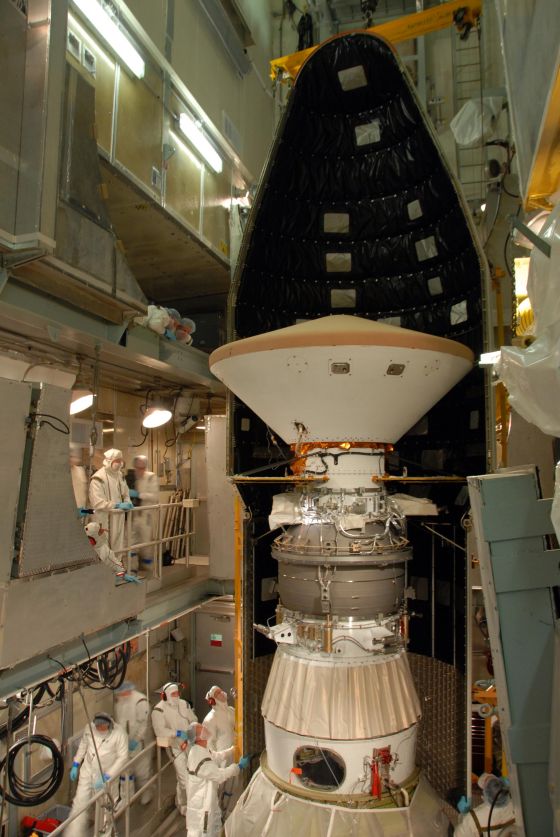
 Integration of the Phoenix Spacecraft into the 3rd stage of a Delta II rocket. Credit: NASA.
|
 Launch on Aug. 4, 2007, 5:26:31 a.m. (EDT). Credit: NASA.
|
The Journey
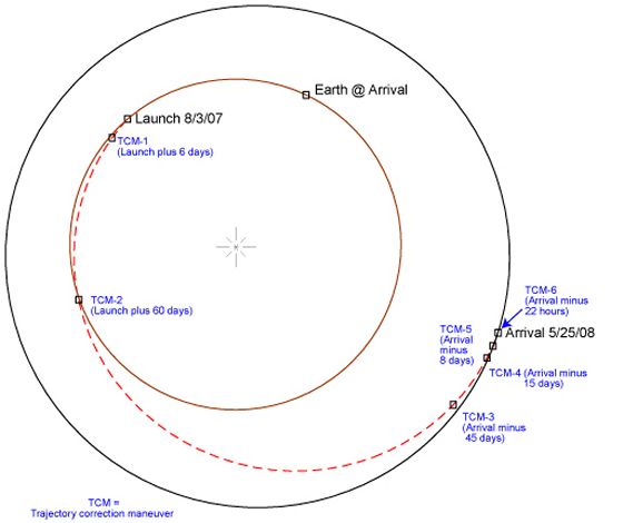
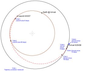 The trajectory from Earth to Mars includes six Trajectory Correction Maneuvers (TCM), cf. figure.
Trajectory of the Phoenix Spacecraft. Credit: JPL.
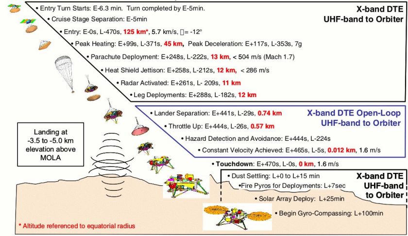
The Landing
The current landing site is located at 127°W, 68.3°N (figure). Entry Descent Landing (EDL, cf. figure) lasts about 8 min. EDL key events include (altitude given in parentheses):
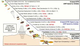
- Parachute deployment (13 km)
- Separation from heat shield (12 km)
- Separation from parachute (740 m)
- Retro rockets fired (570 m)
Entry Descent Landing (EDL). Credit: JPL.
The Spacecraft
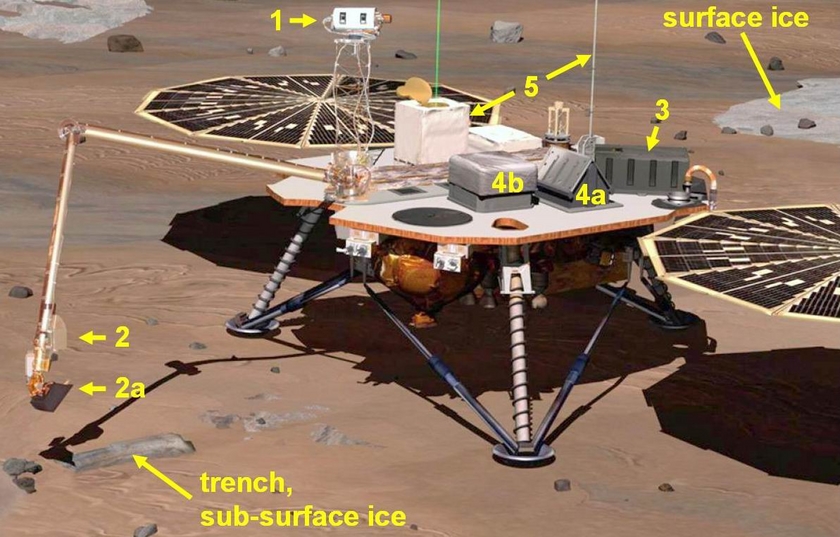
The Phoenix science payload is composed of seven units (figures):
- Robotic Arm (RA), provided by JPL: The RA (configured with a scoop) allows digging down to 0.5 m into the soil
- Robotic Arm Camera (RAC), provided by the Max-Planck-Institut für Sonnensystemforschung (MPS), Katlenburg-Lindau, Germany, in collaboration with the University of Arizona
- Microscopy, Electrochemistry, and Conductivity Analyzer (MECA), provided by JPL with support from University of Neuchatel, Switzerland and MPS, Germany
- Thermal and Evolved Gas Analyzer (TEGA) from University of Arizona and University of Texas, Dallas
- Mars Descent Imager (MARDI) from Malin Space Science Systems (MSSS), California
- Surface Stereoscopic Imager (SSI) from the University of Arizona with three radiometric calibration targets from the Niels Bohr Institute, Denmark
- Meteorological Station (MET) including a Light Detection and Ranging (LIDAR) instrument and pressure/temperature sensors from the Canadian Space Agency as well as a Telltale (wind gauge) from the University of Aarhus, Denmark
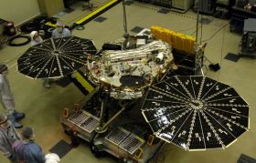 Phoenix lander during integration at JPL. Credit: JPL.
|
 An artist's view of the Phoenix spacecraft on the surface of Mars: 1 = SSI, 2 = RAC, 2a = scoop, 3 = MECA, 4 = TEGA, 5 = MET. Note that TEGA is composed of two subsystems: TA (Thermal Analyzer, 4a) and EGA (Evolved Gas Analyzer, 4b). Credit: NASA (modified).
|
MPS contribution
 RAC
RAC
MECA-OM
Besides development and integration of RAC und MECA-OM focal plane the MPS participates in the Phoenix project with following tasks:
- Active participation in the data acquisition
- Support pre-flight calibration
- Provide image processing software for RAC and MECA-OM
- Operate a MECA-OM focal plane at the MPS for trouble shooting during the mission
Timetable
| Event |
Earth Time |
Mars Time |
Status |
| Launch |
Aug. 4, 2007 |
|
 |
Landing,
Start Primary Mission |
May 25, 2008,
68.3°N, 127°W on Mars |
sol 0, late NH spring (Ls=77°) |
|
End Primary Mission,
Start Polar Climate Phase |
Aug. 26, 2008 |
sol 90, early NH summer (Ls=118°) |
|
| End Polar Climate Phase |
Oct. 26, 2008 |
sol 150, mid NH summer (Ls=148°) |
|
| End of Mission? |
Dec. 25, 2008 |
sol 208 , end of NH summer (Ls=180°) |
|
Phoenix Mission Timetable: NH = Northern Hemisphere. The parameter Ls (Aerocentric Longitude of the Sun) specifies the position of Mars in its orbit around the sun. Ls = 0° and 90° are the beginning of NH spring and summer, respectively.
Related links